
New Hampshire Map
|
 |
 |
Where Is New Hampshire?
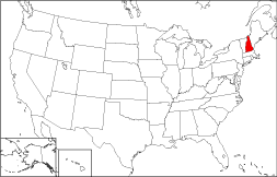
This map shows the location of New Hampshire highlighted in red. The State of New Hampshire is bounded by the Canadian Province of Quebec on the north, by Vermont on the west, and by Massachusetts on the south. It is bordered to the northeast by Maine and to the southeast by the Atlantic Ocean.
New Hampshire Maps
New Hampshire is the 44th largest state in the United States, and its land area is 8,968 square miles (23,227 square kilometers). The state has just ten counties. This New Hampshire map site features road maps, topographical maps, and relief maps of New Hampshire. The detailed, scrollable road map displays New Hampshire counties, cities, and towns as well as Interstate, U.S., and New Hampshire state highways. The pannable, scalable New Hampshire street map can be zoomed in to show local streets and detailed imagery.
New Hampshire Highway Map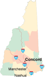 Click on the highway map thumbnail
to view a scalable New Hampshire road map. |
NH Topo Map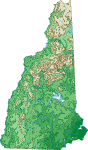 Click map to enlarge.
|
NH Relief Map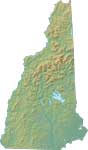 Click map to enlarge.
|
The detailed New Hampshire map and the regional New Hampshire map display cities, roads, rivers, and lakes as well as terrain features. The detailed map shows only the State of New Hampshire, while the regional map shows New Hampshire and the surrounding region.
New Hampshire Infrastructure > New Hampshire Airports
In 2005, the population of New Hampshire was estimated at 1,306,819, which is about 146.1 people per square mile. In 2010, New Hampshire's population rose to 1,316,470 people. More recently, in the 2020 census, the New Hampshire population was 1,377,529. The state's Interstate Highways include I-89, I-93, and I-95.
New Hampshire Topography
New Hampshire was named for Hampshire, England by Captain John Mason. Much of New Hampshire is forested and mountainous. Mount Washington, the tallest peak in the northeast, is known for its fierce winds, which have been clocked at over 200 miles per hour. The primary rivers are the Connecticut, along the Vermont border, and the Merrimack. These rivers are fed by many lakes and streams. Visitors to the Granite State explore history at the Canterbury Shaker Village, and enjoy riding on the Green Mountain Railroad. Visit the official New Hampshire tourism site and New Hampshire Atlas for more New Hampshire travel and tourism information.
Other Maps of New Hampshire
This New Hampshire reference map shows major cities, roads, railroads, and physical features in New Hampshire.Several map publishing companies offer printed maps of New Hampshire. For example, Omni Resources offers several maps of New Hampshire that feature points of interest, airports, and parks, as well as selected local attractions and insets of major New Hampshire cities.
All rights reserved.
Certain maps hereon are © Map Resources or Digital Wisdom.
To facilitate browsing, certain external links will open in new windows.
New-Hampshire-Map.org Editor, State Maps, PO Box 828, Barnegat, NJ 08005.